
Central Washington designated drought conditions
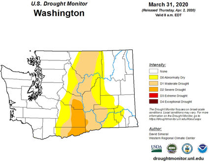
MOUNT VERNON–March brought a mixed bag of weather conditions with mostly near-average snowfall but below-average total mountain precipitation. Average temperatures were slightly below normal with the west-side having the greatest anomaly which helped preserve snowpack through the average peak date of April 1. The most recent forecast through mid-April shows a high probability for near to slightly below normal temperatures and precipitation. NWS 3-month (AMJ) forecast indicates above normal temperatures and below normal precipitation. National Inter Agency Fire Center (NIFC) released their latest Significant Wildland Fire Outlook which indicated above normal chance of wildfire for most of Eastern Washington and normal conditions on the west side. The U.S. Drought Monitor continues to indicate D0-D1 drought designation through all Central Washington with an addition of D2 in the South-Central part of the state.

Snowpack
The April 1 statewide SNOTEL readings were 109% of normal. The lowest readings in the state were at 61% of the 30-year median for April 1 in the Entiat River. The Cowlitz River Basin had the most snow with 132%. Westside medians from SNOTEL, and April 1 snow surveys, included the North Puget Sound river basins with 112% of normal, the Central and South Puget river basins with 113% and 118% respectively, and the Lower Columbia basins with 116% of normal. Snowpack along the east slopes of the Cascade Mountains included the Yakima area with 96% and the Wenatchee area with 98%. Snowpack in the Spokane River Basin was at 111% and the Upper Columbia river basins had 108% of the long-term median.
Precipitation
March precipitation from SNOTEL was generally much below normal statewide with amounts as low as 33% of average at Pope Ridge SNOTEL to as high as 109% of average at Skookum Creek SNOTEL. Alpine Meadows SNOTEL in the Tolt River Basin received the most precipitation with 16.8" or 95% of normal. Water year averages remain near to slightly above normal.
Reservoir
Seasonal reservoir levels in Washington can vary greatly due to specific watershed management practices required in preparation for irrigation season, fisheries management, power generation, municipal demands and flood control. April 1 Reservoir storage in the Yakima Basin was 498,000-acre feet, 97% of average for the Upper Reaches and 178,000-acre feet or 117% of average for Rimrock and Bumping Lakes. The power generation reservoirs included the following: Coeur d'Alene Lake, 89,000-acre feet, 54% of average and 37% of capacity; and Ross lake within the Skagit River Basin at 79% of average and 41% of capacity. Recent climate impacts and management procedures may affect these numbers on a daily or weekly basis.
Streamflow
As we near the apex of winter we can see an increase in streamflow forecast accuracy. However late winter and even spring climate conditions may warrant changes as we move forward. Volumetric forecasts are developed using current, historic and average snowpack, precipitation and streamflow data collected and coordinated by organizations cooperating with NRCS. Caution should be used when using early season forecasts for critical water resource management decisions since governing conditions are likely to change for the better or the worse.