Conceptual plan of Touchet Valley Trail released
-Submitted photo
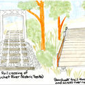
The Touchet Valley Trail's terminus at the Columbia County Courthouse would focus visiting trail users' attention on a number of Dayton's historic attractions, including the Dayton Depot, Caboose Park and the Smith Hollow Schoolhouse. The plan suggests building a retaining wall alongside the rail west of the trestle, to prevent further degradation of the rail bed and provide a safe separation for trail users.
DAYTON–The 30-page Touchet Valley Trail Concept Plan 2020, made available recently to the public and forwarded by the Port of Columbia Commissioners to the trail consultant for further preliminary design work, contains an in-depth study of the 9.7-mile non-motorized recreational trail between Dayton and Waitsburg, offering potential solutions to a number of challenging points along the route.
The plan will "describe possible design solutions addressing project goals, opportunities and challenges," the report indicated. "They are written using the best information available at the time, understanding that some of the concepts could get modified and adjusted as more detailed analysis, design and engineering occurs. Concept Plans are a useful starting point in planning projects, helping to promote consensus among community leaders and stakeholders by articulating goals for development and use of the property. They are also useful documents for securing grants, appropriations and assisting in other fundraising efforts."

The next milestone in the trail planning project will be the 30% design stage, which is described as a preliminary alignment and grading plan that is prepared after surveying, aerial photos, base map preparation, and supplemental survey and right-of-way work is undertaken. This stage in the design is expected to be reached in late 2020, a news release from the Port of Columbia indicated.
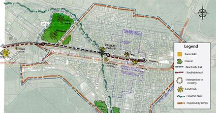
The Touchet Valley Trail (TVT) was divided into four segments: Waitsburg to Huntsville; Dayton; Valley View; and Education and Interpretation, the result of a two-day design "charrette" in October, 2019, which included volunteers from the American Society of Landscape Architects-Washington Chapter (WASLA), volunteers from WSU's Landscape Architecture Program, the University of Washington's Department of Landscape Architecture and community members.
Team 1 tackled "Waitsburg to Huntsville, about three miles from the 'trailhead' in downtown Waitsburg to near the Touchet Valley Airport. Starting from the center of Waitsburg would promote the town as a destination with a potential for restaurants and shopping. "Creating such trail-oriented activities will bring trail users into the core of Waitsburg, and local businesses will see direct economic growth from this connection," the report said.
Two different paths out of Waitsburg's Main Street are proposed, one higher and more northerly, and the other meandering closer to the Touchet River, "essentially creating an in-town loop for walkers."
From a half mile east of Waitsburg, for the next two miles, the team dubbed it "Open Spaces," with a goal of maintaining "a sense of openness." At the beginning and end of this segment, planners suggested planting a small grove of trees, for points of respite. Alternatively, shade structures could be placed, eliminating the shedding and maintenance of trees.
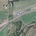
The third segment examined by Team 1 is the last half mile at Huntsville, passing by the south side of the grain elevator, curving 90 degrees to cross the tracks to the north side, encouraging trail riders to slow where the trail crosses Main Road. It could also be another trailhead, the report suggests.
The trail must be at least 25 feet set back from the elevators, and may require fencing.
"Heading east from the grain elevator, the trail could continue on the north side of the track where it could pass through an open flat landscape and where there are a few crossings and a bridge over the Touchet River," Team 1 indicates. "After crossing the bridge, the trail could enter one of the more challenging areas. To the south, Highway 12 and a steep swale which parallels the railroad right of way create a safety concern for trail users. The north side of the tracks could offer a safer alignment making the 50-foot distance between the rails and the Wilbur Ellis chemical facility and the aviation grounds suitable for a trail. Since neither of the properties are fenced from the railroad, a fence along both property lines and the rail corridor should be installed. Planting trees on the north side of the trail in this stretch could help, but getting them established would require water and protection from deer."
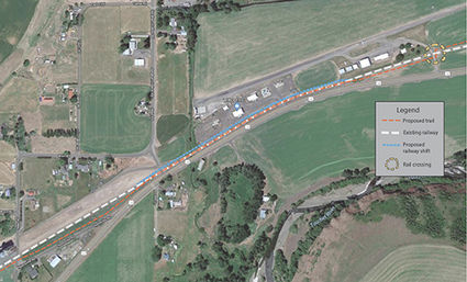
An alternative was also proposed: "In the trail's passage through Huntsville, the railroad tracks could be shifted in order to make space for the trail on the south side of the tracks. This option is preferred by the rail operator and eliminates the need for the trail to cross the railroad in this segment. The tracks could be shifted to the north, allowing the trail to run along the existing rail bed. This could reduce the tight passage of both the trail and the railway in this area and would require shifting approximately 1,300 feet of track. This shift would increase space between the trail and the highway, creating more separation between recreational and industrial uses. The trail could then cross to the north of the tracks at the airport, east of Huntsville."
"Moving a railroad isn't something most people would think of when planning a project like this," said Paul Didelius, owner of Columbia Rail and operator of the Walla Walla Columbia Rail Line, and the company that leases the rail corridor. "By shifting about 1,300 feet of rail, we can create better passage for the railroad, more security for the adjacent industrial users, and maintain an enjoyable recreation experience for trail users."
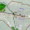
Another team, Team 2, studied the portion from the Columbia County Courthouse westward to Blue Mountain Station, dividing it into three segments: the String of Pearls, the Bridge Trail System and the Woonerf Trail System. The "String of Pearls" refers to the Columbia County Courthouse, the Train Depot, the Caboose Park, and the Smith Hollow Schoolhouse.
"Bridge Trail System" unites the "Pearls" section with the "Woonerf Trail System," west of the river crossing and rail bridge. "The team concluded that the best location to cross the Touchet River would be on the north side of the existing train bridge. The proposal includes a crossing near the Smith Hollow Schoolhouse across Commercial Street, bringing the trail from the south side of the railroad to the north side of the railroad," the report indicates.
"This segment of the Dayton reach is recommended as Phase Three due to costs," it reads. "There are no current planning documents that include this pedestrian access, and as such, currently has no funding availability. It is recommended that the East and West Commercial Street improvements take place first, then offer the connection with this pedestrian bridge at a later date when ample funding opportunities can be explored."
"The proposed bridge would allow the trail to connect to downtown Dayton, diverting foot traffic on a safer and more stable river crossing," the section reads. "Dayton has an interest in connecting the city and extending the trail along the Touchet River, wrapping-around to the golf course and reconnecting the proposed trail further west of the Touchet River. This footpath is already established and is known to locals as the "wild side of the dike." Unlike the rest of the trail built on the Port's property, any extension of this trail would require permission granted by private landowners."
West of the bridge, the "Woonerf Trail System" proposes the trail "would run along the north side of the railroad and the south side of Commercial Street. The woonerf is proposed as a solution to combat a wide variety of issues, including non-compatible existing land uses across the track; high need of street repaving; narrow availability of right-of-way for road expansion/width increase; and more. An additional concern is residential privacy along West Commercial Street. A feasible solution could be the implementation of permeable barriers, such as hedges, in the development of the Woonerf."
A retaining wall is recommended on the north side of the track to prevent further erosion of the rail bed.
A "woonerf" is defined as a "shared and living road" for vehicles, pedestrians, bikes, etc.
The third team addressed the trail from the airport, past the Green Giant viewpoint and on to Blue Mountain Station, focusing on placing the path in the safest and most convenient side of the rail line, and further dividing the section into four portions: Airport to Touchet River; River to Lewis and Clark Trail State Park; State Park to Long's Station; and Long's to Blue Mountain Station.
This segment gave planners more options for trail construction, including graveled pathway for horses alongside the asphalt trail. "Team 3 brainstormed future options that could benefit trail users and visitors. The first option includes enhancements to Dumas Station and the second is a highway crossing at Lewis and Clark Trail State Park to provide accessibility to both sides of the park while avoiding direct pedestrian highway crossing." They envisioned a boardwalk bridge north of the rail bridge, an underpass, sky bridge, flashing pedestrian crossing or a roundabout at the State Park to enhance pedestrian safety. The underpass was discounted due to the high water table and flood hazards. An alternate trail route through Dumas Station Winery's former apple storage building, which could provide shade or shelter from the elements, plus give the winery, and potentially other vendors, marketing opportunities.
Team 4 studied the "Education and Interpretation" pieces, describing the history of the Touchet Valley and its significance to Native American tribes, the Lewis and Clark Expedition's travels in 1806 and the history of Dayton and Waitsburg.
Fifteen points of interest, including agriculture and geology, cultural history, the State Park, Dumas Station Winery, the Green Giant Company, "Earl the Elk," natural history and more were described as possible cultural points to be included. Educational information boards, directional signs and brass mile-marker strips across the trail, and other embellishments were proposed.
Pie charts and graphs of the results of the Summer, 2019, survey are included, as is a four-page "Community Health Profile," developed by the Columbia Valley Health Department, the National Park Service and Port of Columbia.
All public comments received during last year's survey, adjacent landowner meeting, individual meetings, two public meetings, Port Commission meetings, and the design charrette workshop were given to the design teams that worked on the concept plan. Effort was taken to develop a concept plan that incorporated ideas from potential users as well as solutions to concerns that were raised.
"We received some really constructive comments during the public process last year that we worked to address in the conceptual plan," stated Glen Mendel, a long time Dayton resident that serves on the Touchet Valley Trail Steering Committee. "The conceptual plan is intended to help shape the design as it progresses and provide a visual representation of the ideas generated thus far."
A technical assistance grant from the National Park Service (NPS) Rivers, Trails, and Conservation Assistance (RTCA) program helped the Port of Columbia and its partners complete the Concept Plan with minimal spending at the local level, according to the Port of Columbia news release.
The Washington State Department of Transportation (WSDOT) is funding the preliminary design of the trail. The Port of Columbia has contracted with a private consultant firm who is currently working on surveying the rail corridor and sifting through title records and other documents to verify the location of the Port-owned right of way.
-Submitted photo
An alternate plan suggests relocating approximately 1,300 feet of rail line to the north to make room for the trail, a proposal which is favored by the Port of Columbia's rail operator, and one which eliminates one addition crossing of the rail line by the Touchet Valley Trail.
Touchet Valley Trail Steering Committee includes: Meagan Bailey, City of Dayton; Trina Cole, City of Dayton; Dena Martin, Columbia County Planning; Charles Eaton, Columbia County Public Works; Paul Gonseth, Washington State Department of Transportation; Clara Dickinson-McQuary, Washington State Parks; Randy Hinchcliffe, City of Waitsburg; Joy Smith, Waitsburg Commercial Club; Glen Mendel, community member (Dayton); Terry Lawhead, community member (Waitsburg); Genie Crowe, community member (Dayton); Paul Didelius, Columbia Rail owner; Adam Schmidtgall, Anderson Perry; Brian Hansen, Anderson Perry; Shaun Darveshi, Palouse Regional Transportation Planning Organization; Jennie Dickinson, Port of Columbia; Alexandra Stone, National Park Service; and Lucia Portman, National Park Service.