
Water Supply Outlook
It's Dry
Once again Washington experienced a very dry month, in fact a record dry month at many locations. Due to the lack of precipitation and lots of sunshine, many SNOTEL sites on the east side melted out 1-2 weeks early. Higher elevation sites and the sites along the western Cascades seem to have fared better and exhibited normal melt rates. The North Puget Basin was the only area to increase snow percentages, more due to slow melt than anything.
The most recent forecast through mid-May shows a high probability for above normal temperatures and below normal precipitation, with a return to near normal conditions later in the month. National Weather Service 3-month forecast, beginning May 1, indicates above normal temperatures and below normal precipitation. The latest US Drought Monitor indicates an expansion of D0 (Abnormally Dry) to Western Washington following the lack of rainfall over the last two months. D1 & D2 (Moderate and Severe) have also expanded their grip on the east side. (see maps on page 4)

Snowpack
The May 1 statewide SNOTEL readings were 122% of normal, slightly lower than last month. Snow sites in the central belt have begun to meltout, many 1-2 weeks early. The Tolt River Basin held the most snow with 198%. Westside medians from SNOTEL and May 1 snow surveys, included the North Puget Sound river basins with 115% of normal, the Central and South Puget river basins with 174% and 131% respectively, and the Lower Columbia basins with 112% of normal. Snowpack along the east slopes of the Cascade Mountains included the Yakima area with 96% and the Wenatchee area with 115%. Snowpack in the Spokane River Basin was at 86% and the Upper Columbia river basins had 112% of the long-term median.
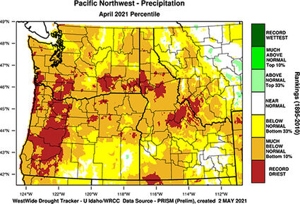
Precipitation
May precipitation accumulation from SNOTEL was much below normal across the entire state. Individual stations ranged from 53% to a low of 14%. Many sites recorded record low rainfall last month. Statewide water-year average was near normal as of May 1. SNOTEL collects all form of precipitation including, rain, snow or sleet and hail.
Reservoir
Seasonal reservoir levels in Washington can vary greatly due to specific watershed management practices required in preparation for irrigation season, fisheries management, power generation, municipal demands and flood control. May 1 Reservoir storage in the Yakima Basin was 583,100-acre feet, 96% of average for the Upper Reaches and 175,300-acre feet or 98% of average for Rimrock and Bumping Lakes. The power generation reservoirs included the following: Coeur d'Alene Lake, 154,300-acre feet, 68% of average and 65% of capacity; and Ross lake within the Skagit River Basin at 81% of average and 42% of capacity. Recent climate impacts and management procedures may affect these numbers on a daily or weekly basis.
Streamflow
While seasonal forecasts this time of year are generally quite robust abnormal climate conditions can still affect final outcomes. The lack of or unavailability of certain data sets can also reduce accuracy (Example: failure to continue monthly measurements at historic long term manual snow courses can effect calculated runoff from major drainages of a large basin) Volumetric forecasts are developed using current, historic, and average snowpack, precipitation and streamflow data collected and coordinated by organizations cooperating with NRCS. The lack of precipitation last month highly effected normal runoff throughout the region, however irrigation releases and a mid-month temperature spike helped bolster some recorded flows.