
Moist air enters region
A little relief
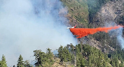
-Submitted photo
The Green Ridge Fire is about 18 miles southeast of Dayton and has steadily grown to its 6,800 size as of this week's press deadline. A cooler air mass, with moisture, moved in to the area Tuesday, moderating temperatures and injecting humidity into the mix as some 320 On July 23, air and ground resources worked together to contain a 75-acre spot fire in the Meadow Creek area.
DAYTON–The Green Ridge Fire continues to burn and expand to 6,799 acres with containment of 15% in the Blue Mountains, about 18 miles southeast of Dayton as the crow flies, as of press deadline this week. Anticipated shortages of fire-fighting resources will lengthen the time until the fire is considered out or controlled.
Weather continues to be a factor in the fire which began July 7 following a lightning storm across the region. As Monday, July 26, progressed, there was an influx of mid-level moisture coming from the southwest which brought cloudy skies and a subtle moistening of the air mass. Most of the light showers with this moisture remained south of the fire over northeastern Oregon. Winds were light and terrain-driven through much of the day, with light breezes around 15 mph in the afternoon.
Moisture rotating around the Four Corners high began to stream across southeastern Washington on Tuesday with a chance for on and off sprinkles. The cloud cover is expected to help keep afternoon temperatures a few degrees cooler and yield higher humidity values as the air mass continues to moisten. Westerly winds became breezy Tuesday afternoon and evening with the potential for gusts around 20 mph.

Some 320 firefighting personnel are on the job. Fire-fighting strategy includes continuing to utilize air resources when available to check the fire's edges and hold fire in strategic locations in order to implement primary and alternative control lines. Hand crews and heavy equipment are continuing prep work on prep FS road 46 and FS 4608 on the south and west side of the incident (Divisions A, G, K and M), under the leadership of CA Team 12, which relieved Pacific Northwest Team 3 Monday evening.
Leadership is coordinating with firing group to evaluate opportunities to compartmentalize established fire on the west side of 4713 (Meadow Creek), and setting up hose lays in Divisions K and M (North end). Fire evaluators will continue to scout line opportunities along trails, ridges, and ridge tops in the Wenaha-Tucannon Wilderness.
Long-term planning and significant resource shortages will extend time frame of resource demobilization date.
The fire's primary spread direction is northwest in the Meadow Creek drainage and some flanking/backing north and south, toward H-34, H-39 and DP-245 and DP-242. Terrain and fuel is the biggest contributor to spread. Surface fire is comprised of backing, flanking, creeping and smoldering. After inversion lifts or smoke clears, firefighters anticipate increased activity with single and group torching, short crown runs with possible spotting up to 0.10 mile.
There has been moderate spread to the East and North in the burn scar left from the Columbia Complex Fire in 2006, slowing at the top of the ridge but spotting over to lee side. Surface fire is comprised of backing, flanking, creeping and smoldering thorough the dead or down fuels from the previous fire.
Another fire garnering attention is the Elbow Creek Fire about 17 miles northwest of Wallowa, Ore., burning on both sides of the Grande Ronde River and is on or threatening Umatilla National Forest lands, Wallowa-Whitman National Forest lands, Vale District Bureau of Land Management lands and Oregon Department of Forestry protected lands. The fire of unknown origin was reported on Thursday, July 15 and is burning in grass and timber.
Two single residences were destroyed during the course of the fire, as well as four minor structures.
The Elbow Creek Fire is approximately 22,790 acres and 38% contained. More firefighting personnel, totaling 976, and equipment arrived Tuesday, filling all fire-line resource needs.
The Elbow Creek area continues to be the focus for firefighters. Crews continue to suppress spot fires in the area and tie a short section of containment line together.
As of Monday evening, the priority is finishing the last bit of burnouts. Due to the incredible work of the firefighters, fire progression has been stopped in the Sickfoot Creek drainage. The focus here will now transition to mop-up operations.
To the east of Sickfoot, in the southern corner of the fire perimeter, a couple of minor spot fires were caught Monday. These have been taken care of but reminds crews to stay diligent, even in times of stable fire conditions.
The conditions on the east side of the fire have not changed. Tomorrow's operations will include deeper interior mop-up as well as strengthening of the fire line.
The 6213 Road will be opened briefly tomorrow to allow wildland fire investigators access to complete their investigation of the fire.
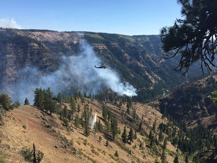
-Submitted photo
The Elbow Creek Fire is approximately 22,790 acres and 38% contained. More firefighting personnel, totaling 976, and equipment arrived Tuesday, filling all fire-line resource needs.
Weather patterns will remain consistent with what they have been, although temperatures will lower slightly. Winds will remain relatively light, and humidity will increase a little. The forecast does predict a very slight chance of rain and thunderstorms during Tuesday's operational period.
Evacuation levels within Wallowa County remain unchanged for now.
Oregon Dept. of Forestry IMT Team 2 is in command.
There are 21 wildfires burning in Washington state totaling 392,000 acres. The nation's largest fire is the Bootleg Fire in southwest Oregon, weighing in at 410,731 with 53% containment.