
Green Ridge Fire burning freely in rugged terrain
-ORUMF
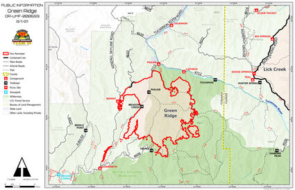
COLUMBIA COUNTY–Oregon Umatilla Forestry (ORUMF) reported that firefighters continue the fight to contain the ongoing July 7, 2021, lightning strike Green Ridge Fire. According to the ORUMF, crews recently contained a twenty-two-acre spot fire on the west side of the 46 Road about two miles north of Godman Trailhead. Every effort is being made to protect the numerous assets at risk which include Mill Creek Municipal Watershed, plantation reforestation sites, sensitive plants, recreation areas, fisheries, numerous cultural, archaeological, and historic sites, farming, agricultural lands, a RAWS site and a repeater site.
Secondary control lines are also being established by improvement of existing roads, trails, and natural terrain features. Structures at the Historic Godman Guard Station and Fire Lookout are being protected through the use of protective fire wrap.
Firefighters continue working the strategy of the 'anchor and flanking', using the northwest portion of the fire as the anchor and constructing containment lines from that area along the north and west perimeter of the fire. Less active areas along the perimeter allow for placement of containment lines immediately adjacent to the fire perimeter. Areas unsafe for personnel to access or lack of personnel require burning out fuel between the main fire and containment lines. Presently, the Green Ridge Fire is 15% contained.

The Asotin County Lick Creek fire is 90% contain as of August 1, 2021. The fire started on July 7, 2021 from a lightning strike and has involved 80,392 acres.
Fire crews have been working diligently over the past few weeks to bring the Lick Creek fire under control. With the recent storm Saturday, July 31, 2021, the area experienced 0.12" of rainfall which aided in the continuing firefighting efforts. With the exception of a small, six-acre spot fire which was fought aggressively and quickly, the area is now 90% contained. Crews will continue to mop up pockets of heat interior and patrol the perimeter until full containment is achieved. A Burned Area Emergency Response team continues its efforts for the fire. The team's work will allow for long-range forecasting and preparation of mitigation measures in areas where the risk of runoff and flooding can take place. Level 1 evacuation remains in place in Garfield County.
An evacuation level II notice was issued on July 29 by Columbia County's sheriff's office which remains in effect for the area south of the previous Level I evacuation in Columbia County. The Level II evacuation extends east to the forest boundary, including Bald Butte Mountain and south to the Columbia County-Wallowa County state border; west to the forest boundary and north to Chase Mountain; from Chase Mountain, to Middle Point Trailhead to Midway Campground. Additionally, a Level I evacuation notice remains in effect for everywhere north and west of Chase Mountain and Midway Camp in the forest boundary.
If you have questions, please call the Columbia County Sheriff's Office (509-382-1100; or 509-382-2518).
Contact Garfield County Emergency Management Director, Tina Meier, or Sheriff Drew Hyer (509-843-3494) if there are questions pertaining to the Garfield area.
All Forest Service lands, roads, and trails in the Umatilla National Forest are closed.