Umatilla National Forest issues temporary road and trail closures
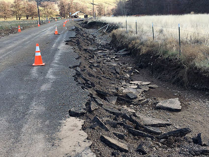
-Chronicle photo
The United States Forest Service (USFS) has temporarily closed several roads and trails in the Pomeroy Ranger District due to water damage from flooding on February 6. Part of the Tucannon Road that passes through the Wooten Wildlife Area is one of those roads. It is currently closed above the Hatchery turn-off. Access to Camp Wooten and several other state and federal campgrounds are also restricted, with only WDFW's campgrounds 1, 2, and 3 open right now and only four lakes that will be stocked and open to fishing; Blue Lake, Spring Lake, Rainbow Lake, and Deer Lake.
PENDLETON–The Umatilla National Forest has temporarily closed several roads and trails on the Pomeroy and Walla Walla Ranger Districts due to substantial damage caused by the flooding event on Feb. 6, 2020. Flood damage is widespread and until critical repairs can be completed, Forest staff have implemented road and trail closures in the areas that received the heaviest impacts. These areas include the Tucannon, Umatilla, and South Fork Walla Walla Rivers. Forest staff are currently working on options to secure funding and resources to conduct repairs.
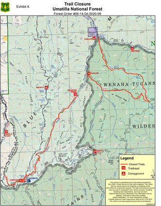
The following road and trail closures are in effect until further notice:
Pomeroy Ranger District
Tucannon River: Portions or all of Forest Service Roads 47, 4712, 4620 and 4713 are closed, as well as the Meadow Creek Trail #3123, Panjab Trail #3127 and Rattlesnake Trail #3129 (see maps for details). The Little Tucannon bridge is compromised and will need further evaluation to determine the extent of the damage. Water is currently flowing around the bridge at the junction with Forest Service Road 4620, which is a popular road that accesses Lady Bug Campground and the Panjab Trail #3127. Access to Camp Wooten and some other state campgrounds are also restricted and the Tucannon Campground has experienced moderate damage.
Walla Walla Ranger District
Umatilla River: Forest Service Road 32 is closed at the Forest boundary near Corporation Guard Station to where the road turns south away from waterways toward Ruckel Junction at the southern end of the North Fork Umatilla Wilderness. Forest Service Road 32 has extensive damage, including approximately five areas where the road is completely gone. At least a dozen or more areas were identified where side channels have distributed debris into the roadway, or the river has created scours in the road.
South Fork Walla Walla River: The entire trail system surrounding the South Fork Walla Walla River is closed, including:
-South Fork Walla Walla trail head and trail and Deduct trail head #3225
-Table Springs trail head and trail #3223
-Rough Fork trail head and trail #3227
-Burnt Cabin trail head and trail # 3226
-North Fork Walla Wall trail # 3222
-Cow camp saddle trail # 3224
Multiple areas were identified where the South Fork Walla Walla River has either washed out the trails within this area or Forest staff identified debris slides along the trails that will need repair.
Closure signs will be posted on the ground and detailed maps of the closure information is available on the Forest website and at any Forest office.
Umatilla National Forest officials urge forest visitors to plan ahead and contact their local ranger district prior to starting their trip. Most forest roads are still not accessible due to mud, snow or snow drifts. In addition, traveling on thawing, saturated, and muddy roads can result in resource damage and serious safety concerns, especially if visitors are unprepared. Forest conditions are dynamic this time of year and likely to change throughout the day and week. The public is encouraged to monitor the Umatilla National Forest Facebook page and website for updates on flooding.
As a reminder, many places in the Blue Mountains have limited or no cell phone coverage. Forest visitors should always be prepared to spend the night in the forest with warm clothing, food and plenty of water. Before heading out, always let someone know where you are going and when you expect to return.
Additional information about the Umatilla National Forest is available at https://www.fs.usda.gov/umatilla.