Lightning storm sparks several fires in Blues
-Submitted photo
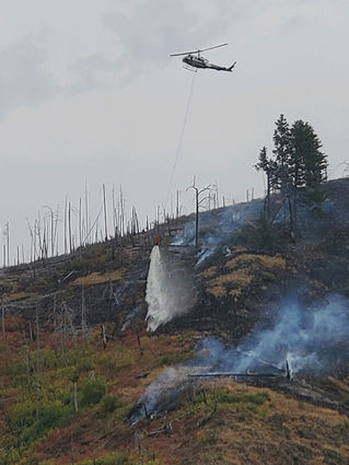
Aerial resources have been deployed to assist on-the-ground fire fighters quell hot spots in the approximately 400-acre Rattlesnake Fire, one of a number of lightning-caused fires following an August 19 thunderstorm.
POMEROY–As of press time Tuesday night, August 25, the larger or more active fires in the Meacham Complex are the Horse Fire, the Hager Ridge Fire, the 896 Fire, and the Rattlesnake Fire.
The Rattlesnake Fire is burning on the Pomeroy Ranger District, approximately twenty miles south of Pomeroy and thirteen miles southeast of Dayton.
The Rattlesnake Fire is currently estimated at approximately 400 acres and is burning southward into the Tucannon Wilderness, in a fifteen-year-old fire scar in extremely steep terrain.
As the fire consumes dead and downed timber from the previous fire, some of this material is falling and rolling downhill, the Northern Rockies Type 2 Incident Management Team reported. The IMT is actively managing this hazard to ensure personnel safety. Firefighters, are being assisted with helicopter water drops to cool down hot spots.
Fire managers are currently developing a suppression strategy. However, limited access (because of spring 2020 flooding) is hampering some efforts, and the local District is trying to complete temporary repairs to improve firefighter access to the fire.
Firefighters initiated suppression efforts Sunday afternoon, August 23, on the Rattlesnake Fire, located a quarter mile south of Panjab campground. A 12-person crew was transported to the fire via helicopter and began building containment lines along the southeastern edge of the fire. Two helicopters supported ground resources by dropping water on the fire to slow spread and cool hot spots.
The Rattlesnake Fire at that time was estimated at 250 acres and was burning upslope toward the south and southeast in between two steep ridges within the 2006 Columbia Complex fire scar. The fire is burning in grass, brush, snags and timber with dead and down trees. Fire was most active on the southeast and northwest edges of the fire.
Contractors with heavy equipment and local forest engineers completed repairs on the approach to the Little Tucannon Bridge on FSR 47 (which was damaged in the February flood event) and are now working on opening the road up to the Panjab campground. The objective of this work is to gain firefighter access into the fire. A 20-person crew had arrived and will hike in once access on FSR 47 has been restored.
The Northern Rockies Incident Management Team 3 that is managing the Meacham Complex took over command of the Rattlesnake Fire on Monday, August 24 at 6 a.m. The Forest will also implement a temporary road, trail and area closure surrounding the Rattlesnake Fire for public safety.
Firefighters further reinforced containment lines and continued mop up on many of the fires in the Meacham Complex, as the series of lightning-sparked forest fires has been named.
Crews working on the Hager Fire have secure containment line around much of the fire's perimeter and have held that fire to approximately 57 acres.
Hand crews and air resources continued to cool hot spots in heavy fuels along the Horse Fire's southeast flank. Firefighters have rough containment line around much of the Horse Fire's perimeter and are working inward from those lines, mopping up hotspots to further secure containment. The Horse Fire is currently estimated at 169 acres.
Firefighters working on the 896 (Horseshoe Ridge) Fire have constructed handline around much of the fire; however, in order to help secure containment lines where direct line construction was not possible, they conducted a small burnout operation along the fire's southern/southeastern perimeter. As the 896 Fire backed downhill towards the Union Pacific Railroad line, crews patrolled that fire edge for hazards to the suppression activities and the rail lines. The 896 Fire is currently estimated at about 40 acres.
Tuesday, hand crews on the Hager Ridge, Horse, and 896 fires will continue to work on strengthening containment lines and mop-up, working inward from the fire perimeter to cool hotspots. In some areas, efforts to fall dangerous snags (dead trees) will continue before crews can progress further with mop-up. Air resources (including one incident-assigned helicopter, as well as other helicopters borrowed from other areas, and, if needed, single engine air tankers-SEATs) will continue to support firefighters on the ground by dropping water to cool hotspots and reduce fire spread, or, if needed, by applying retardant to inhibit fire spread.
Hot and dry conditions are expected to persist throughout the week. Fire officials want to remind everyone that the current fire danger rating remains at HIGH and Public Use Restrictions involving chainsaw use are in effect.
Regulated closures have also been implemented on State and private lands protected by Oregon Department of Forestry (ODF) in northeast and central Oregon. Similar restrictions may be in effect on State and private lands protected by the Washington Department of Natural Resources (WA-DNR).
For more information regarding Restrictions, please contact the Umatilla National Forest information hotline at (877) 958-9663.